'%3e%3cpath%20d='M34.1406%205.85938C30.3906%202.10547%2025.3047%200%2020%200C14.6953%200%209.60938%202.10547%205.85938%205.85938C2.10938%209.61328%200%2014.6953%200%2020C0%2025.3047%202.10547%2030.3906%205.85938%2034.1406C9.61328%2037.8906%2014.6953%2040%2020%2040C25.3047%2040%2030.3906%2037.8945%2034.1406%2034.1406C37.8906%2030.3906%2040%2025.3047%2040%2020C40%2014.6953%2037.8945%209.60938%2034.1406%205.85938ZM37.0117%2023.543H31.1602V13.5391H27.6328V19.9414C28.1211%2020.6914%2028.3711%2021.582%2028.3711%2022.5625V22.625C28.3711%2023.668%2028.1172%2024.6055%2027.6328%2025.4297V26.6094H36.082C33.4883%2032.9375%2027.2891%2037.3789%2020.0039%2037.3789C10.3711%2037.3789%202.62109%2029.6289%202.62109%2020C2.62109%2010.3711%2010.3711%202.62109%2020%202.62109C29.6289%202.62109%2037.3789%2010.3711%2037.3789%2020C37.3789%2021.1484%2037.2617%2022.2656%2037.0508%2023.3477C37.0391%2023.4141%2037.0234%2023.4766%2037.0117%2023.543Z'%20fill='white'/%3e%3cpath%20d='M22.3086%2018.5352C20.4336%2018.125%2019.9531%2017.8398%2019.9766%2017.1836V17.1406C19.9766%2016.6992%2020.3477%2016.2148%2021.4023%2016.2148C22.582%2016.2148%2023.8867%2016.6797%2025.0781%2017.4766L26.8516%2015.0195C25.4453%2013.8906%2023.707%2013.3398%2021.5547%2013.3398C18.5195%2013.3398%2016.4375%2015%2016.4063%2017.4766V17.5352C16.3633%2020.2617%2018.5859%2020.9805%2021.293%2021.6016C23.0391%2021.9766%2023.5703%2022.3164%2023.5703%2022.9609L23.5469%2022.9766C23.5469%2023.3906%2023.2578%2023.7031%2022.7852%2023.8359C22.5742%2023.9062%2022.1289%2023.9727%2021.5156%2023.9727C20.7617%2023.9727%2019.7539%2023.8633%2018.6328%2023.4844C18.0898%2023.2891%2017.4727%2023.0039%2016.8047%2022.6133L20.1406%2026.625C20.2813%2026.6602%2021.0977%2026.8516%2021.7734%2026.8516C25.0039%2026.8516%2027.0859%2025.2461%2027.1094%2022.6328V22.5703C27.1602%2020.1133%2025.2148%2019.1719%2022.3086%2018.5352Z'%20fill='white'/%3e%3cpath%20d='M5.24219%2013.5664V26.6133H8.75391V23.7578L10.2969%2021.9531L14.2031%2026.6133H18.3867L12.3555%2019.5195L17.4023%2013.5664H13.4531L8.75391%2019.0586V13.5664H5.24219Z'%20fill='white'/%3e%3c/g%3e%3cdefs%3e%3cclipPath%20id='clip0_97_2430'%3e%3crect%20width='40'%20height='40'%20fill='white'/%3e%3c/clipPath%3e%3c/defs%3e%3c/svg%3e)




- A central Utah storm on Saturday produced 100 mph gusts, not a tornado, the National Weather Service reports.
- The storm caused significant damage to homes, rail cars and vegetation.
- Officials, including Utah Rep. Celeste Maloy, assessed the damage and offered support.
LYNNDYL, Millard County — A storm that passed through central Utah on Saturday did not produce a tornado, but it generated peak wind gusts of 100 mph that caused all sorts of damage in the area, federal forecasters have determined.
The wind event developed near Sugarville, Millard County, a small unincorporated community north of Delta shortly before 4:30 p.m. It eventually grew to over 17 miles in length and 2 miles in width before finally subsiding near Leamington, Millard County, to the east a little more than a half-hour later, according to a report of the severe weather event compiled by the National Weather Service.
Gusts peaked between 80 mph and 100 mph from "straight-line winds," creating considerable damage near Lynndyl along the way.
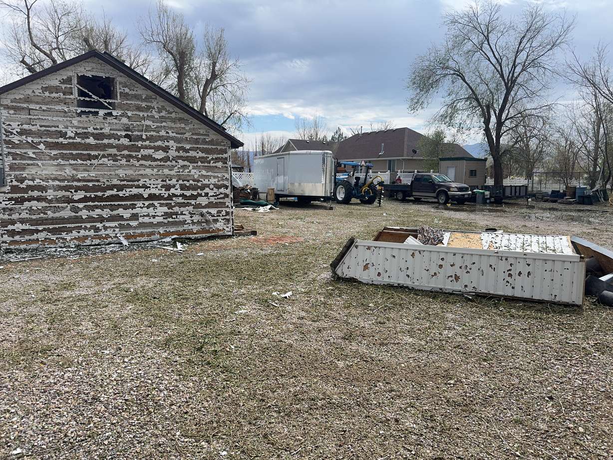
Nearly three dozen empty rail cars blew over, while homes in the area received "immense siding, window and roof damage" from the wind and hail. Some hail nearly reached the size of a golf ball from the event, the agency wrote.
"The wind-driven hail also stripped trees and much of the vegetation in town of their leaves," the report noted, adding that numerous trees were uprooted or snapped, while many vehicle and home windows were smashed in or blown out by wind-driven hail.
Corn in a field near the town, which was nearing harvest, was "shredded" by the event, with snapped stalks and other damage.
Experts said some of the damage was consistent with 100 mph winds, which would be EF-1 on the Enhanced Fujita scale, but there wasn't enough data to support a tornado touching down.
The report is based on damage assessments and radar reviews. Interviews with residents, along with photos, videos and a map of damaged areas, went into the research for the report, National Weather Service meteorologist Alex DeSmet told KSL on Sunday.
It's unclear how costly all the damage is.
Utah Rep. Celeste Maloy, Utah Attorney General Derek Brown and Wade Garrett, vice president of the Utah Farm Bureau, toured the damage on Sunday, posting videos of it on social media. They came to see how they could assist the community affected by the wind event.
"This has been just a devastation. It just hit like crazy," Brown said, as the trio stood in the cornfield that was torn apart. "Some of these folks have insurance, some don't, but we just came from the downtown area of the city where (there are) a lot of people there just coming together to pick things up."