Estimated read time: 2-3 minutes
This archived news story is available only for your personal, non-commercial use. Information in the story may be outdated or superseded by additional information. Reading or replaying the story in its archived form does not constitute a republication of the story.
AMERICAN FORK CANYON — If you live along the Wasatch Front and need a quick break from the hustle and bustle of civilization, head up American Fork Canyon and hike the Tibble Fork Trail.
American Fork Canyon has several excellent hikes, but access roads to several of them are currently closed, including state Route 92 (also known as the Alpine Loop.) If you are wanting to tackle a hike earlier this season, the Tibble Fork Trail is currently accessible. However, the trail is quite muddy and is currently closed to mountain bikers and horses. Because of the wet conditions, hikers should wear sturdy shoes and be sure not to leave the trail so as to eliminate damage to the area.
The Tibble Fork Trailhead is located at the southeast corner of the reservoir (trail No. 41).

The trail has steep switchbacks for roughly the first mile of the hike, but it offers beautiful views of Tibble Fork Reservoir and the surrounding mountains. The trail eventually opens into a beautiful mountain meadows with a picturesque view before continuing into the trees.
Hikers continue to walk up a gradual incline for roughly another mile before reaching a trail intersection. At the trail intersection, hikers have several options. They can continue going straight on the Tibble Fork Trail, which continues for several miles before entering the Little South Fork campground area, or the hikers can turn right and follow the Mud Springs Trail (No. 173), which continues south toward the Salamander Flat area.

I recommend turning left at the intersection and taking the Mill Canyon Trail (No. 40) back to the reservoir. It makes for a nice, roughly 5-mile loop. After the intersection, the trail runs for about 2.5 more miles on a steep descent so you get a break from all the up-hill climbing.
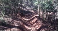
The Mill Canyon Trail is shaded for most of the hike so it keeps you nice and cool. There are also several dead trees that have fallen across the trail that hikers will need to scramble over. Because the hike is quite steep and there are several areas where the trail has eroded into a deep wash, I would not recommend this hike for small children.
Once you reach the bottom of the mountain, you will continue on the Mill Canyon Trail, which eventually runs along the river. Due to the current runoff, the river is quite high and has flooded some areas of the trail, so be careful and watch your step.

Hikers will eventually cross a bridge across the river and will continue walking along the road until they make it back to their vehicle parked at the Tibble Fork Reservoir.
Because American Fork Canyon is managed by the National Forest Service, hikers will need to either have a pass or will need to pay $6 to enter the canyon.
Distance: 5 miles roundtrip
Time: About 2 hours
Difficulty: Moderate
Related Stories: