Estimated read time: 1-2 minutes
This archived news story is available only for your personal, non-commercial use. Information in the story may be outdated or superseded by additional information. Reading or replaying the story in its archived form does not constitute a republication of the story.
SALT LAKE CITY — This past weekend's balmy weather is surrendering to cold, rain, wind and snow brought on by a Pacific storm front due to pounce on much of the state.
Rain was expected to arrive as early as Sunday evening across Northern Utah, according to an alert issued by the National Weather Service in Salt Lake City, with snow falling in the mountains at the 9,000 foot elevation.
Snow levels will continue to drop throughout the next few days in the northern region of the state.
With valley accumulations sporadic, but likely, homeowners should also be aware that trees that have not yet dropped their leaves may litter landscapes and property with downed limbs.
In west central and southwest Utah, a high wind warning in effect until 10 p.m. Monday advises travel for high-profile vehicles and others is potentially dangerous. Gusts could reach up to 60 mph along I-15 in Millard and Beaver counties, particularly, and U.S. 6 and U.S. 50 in the Delta region, as well as state Route 21 and state Route 56. Blowing dust may reduce visibility and any wind-sensitive operations could be impacted.
The National Weather Service warned that the accumulation of leaves and water may create problems for drainage systems in urban areas, leading to the ponding of water on roadways.
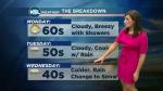
By Wednesday, it will be downright chilly, with highs in the northern valleys expected to be in the 40s. KSL Meteorologist Lynae Myer says it's going to feel a lot different.
"(It's) going to seem more like end-of-November temperatures rather than October," she said. "So for those who have kids that grew out of their winter coats, they've got about 36 hours to get their kids new coats."
It will stay chilly into Friday, before it starts to warm again.
Weather watchers are warning of a "hard freeze" that will begin across much of the region Wednesday and enduring until the pattern snaps. Lows will dip to the freezing mark, or a few notches below.
The good news for skiers and water managers is that the storm is expected to deliver the season's first good helping of snow to the mountains, where there could be "significant" accumulations, according to the weather service.
Contributing: Andrew Adams


