Estimated read time: 2-3 minutes
This archived news story is available only for your personal, non-commercial use. Information in the story may be outdated or superseded by additional information. Reading or replaying the story in its archived form does not constitute a republication of the story.
SALT LAKE CITY — Dismal snowpack throughout Utah and the rest of the country means for the first time in four years, there's not a high risk of major or record-setting spring flooding.
As Utah settles in for warmer temperatures this week, the majority of the state is dealing with below-average snowpack that is not predicted to cause farmland-flooding damage from over-flowing creeks or rivers.
The National Oceanic and Atmospheric Administration released its nationwide seasonal spring flooding outlook through June and said the coming months will not duplicate last year's historic and prolonged flooding experienced in the central and northern United States.
An early snowmelt that has played out in both Utah and elsewhere — coupled with below-average snowpack — means river and stream levels are normal to below-normal.

In Utah, for example, lower-elevation mountain snow has already started to melt off, said Kevin Werner, a hydrologist with the Colorado River Basin Forecast Center.
"Assuming we don't see another cold, wet April like we did last year," mountain streams and creeks will hit their peak much earlier, he added.
While weather and water watchers say heavy spring rains are a potential game-changer for flooding, especially in the Ohio River basin, the overall flooding risk remains in the normal range for the rest of the country.
Puny snowpacks are setting up much of the Western region to persist in drought conditions, with an expansion of problems into the Southwest for the spring, according to the NOAA.
While the national agency's drought map paints a grim picture for Utah, Werner said the time to panic is not here — at least yet.
"If you look at it like a bank account, we have a lot of water in our bank account from the last water year — and in terms of reservoirs — we are at normal or above normal capacity," Werner said.
Those water storage levels will be good insurance for the majority of the state through the coming months as temperatures climb, he added.
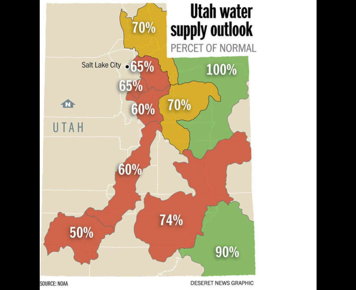
The reservoirs are the safety net to a water volume supply in most mountains of Utah that is hovering in the 50 percent to 70 percent of normal range, said Brian McInerney, hydrologist with the National Weather Service in Salt Lake City.
- Arizona -- is particularly vulnerable; did not see the big water year in 2010-2011 like much of the region did
- Texas and New Mexico -- will struggle
- California -- had anemic precipitation nearly all season, but recent storm boosted its snowpack in the Sierras from 34 percent of average to 46 percent of average
As an example, McInerney pointed to the Virgin River Basin in southern Utah, where only half the volume of water the region receives on average will flow out of the mountains in the runoff season.
"I think what we need to take into consideration was that last year was a banner year, we filled all sorts of areas — we filled Bear Lake 11 feet," McInerney said. "That is the nice part of this whole story."
Werner cautioned that time will tell how much Utah will have to worry about water supplies — as the summer marches into fall — and what kind of storm activity the seasons bring.
"That's when you could see yellow flags."
Email:aodonoghue@ksl.com


