
Estimated read time: 3-4 minutes
This archived news story is available only for your personal, non-commercial use. Information in the story may be outdated or superseded by additional information. Reading or replaying the story in its archived form does not constitute a republication of the story.
SALT LAKE CITY — Utah is expected to have a fresh sheet of snow to begin the new year.
A winter storm warning for all of northern Utah and the Wasatch Front will go into effect at 5 a.m. New Year’s Day, as several inches of snow are expected to blanket the region’s valleys, and even more snow is forecast for mountain areas throughout the day. The warning will last until 11 p.m. that night.
The National Weather Service has also issued a winter weather advisory for most of central Utah, including Delta and Manti. A hazardous weather outlook was issued for the remaining parts of the region and southwestern Utah.
The storm is projected to affect northern Utah first before moving south across most of the state. The system has already dumped rain and snow across the Pacific Northwest and is expected to reach Utah by about 6 a.m., said KSL meteorologist Grant Weyman.
The National Weather Service warning says the northern Wasatch Front and Cache, Salt Lake and Tooele valleys are projected to receive 4 to 8 inches of snow. The agency also projects upward of 2 feet of snow in the Wasatch mountains.
Nephi and Manti are each expected to receive 4 to 6 inches of snow, while places as far south as Cedar City may receive a brushing of snow, according to the weather service.
“There could be some lingering snow heading into Thursday, but I think the majority of those totals will fall before 11 p.m. and midnight (Wednesday),” Weyman said.
The storm will likely make any New Year’s Day travel difficult. The warning states motorists should expect slick and snow-covered roads across northern Utah and may find travel to be “very difficult.”
“One nice thing is New Year’s Day, with not a lot of people out, it’s ideal timing not to have it on a big commuting day or anything like that,” Weyman said.
Forecasts for the rest of the state can be found on the KSL Weather page.
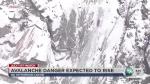
Avalanche threat expected to be high
The New Year’s storm will also give Utah’s ski resorts a welcomed boost with the amount of snow expected. However, avalanche forecasters are urging caution for anyone heading to the mountains for New Year’s Day.
Utah Avalanche Center officials said the storm is expected to bring heavy snowfall and strong winds, which will likely lead to considerable to high avalanche danger within the Bear River, Manti, Wasatch and western Uinta mountains beginning New Year’s Day and heading into Thursday.
Winter Storm Warning for the mountains on New Year’s Day through Thursday morning. This will bring heavy snowfall and strong winds, creating a rapidly rising avalanche danger. CONSIDERABLE TO HIGH DANGER IS EXPECTED.
— UtahAvalancheCenter (@UACwasatch) December 31, 2019
“If folks are going to be heading into the backcountry, they need to be able to recognize avalanche terrain and avoid being on or beneath steep mountain terrain,” said Drew Hardesty, a Utah Avalanche Center forecaster. “The key point of that is if they’re going to be out-of-bounds of our world-class ski resorts, they’re going to be heading into considerable to high avalanche terrain.”
Contributing: Randall Jeppesen, KSL NewsRadio