
Estimated read time: 4-5 minutes
This archived news story is available only for your personal, non-commercial use. Information in the story may be outdated or superseded by additional information. Reading or replaying the story in its archived form does not constitute a republication of the story.
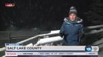
SALT LAKE CITY — Amid an unusually warm and dry Utah winter, a snowstorm pounded the Wasatch Front on Monday causing chaos on the roads and rejoicing at the ski resorts.
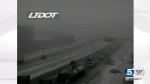
The late-night and early morning blizzard snarled traffic and caused delays during the Presidents Day commute and persisted throughout the afternoon as crashes continued to stack up.
As of 3:30 p.m., the Utah Department of Public Safety reported 458 crashes along Wasatch Front counties. Of those crashes, four involved UHP trooper vehicles being hit, though no troopers were hurt, UHP reported. Any injuries in other crashes were minor.
The National Weather Service issued a winter storm warning along the I-15 corridor, warning of heavy snow initially until 9 p.m. Monday, but the service later extended it to 9 a.m. Tuesday for the Salt Lake and Tooele valleys and Utah County.
As of 6 p.m., the agency reported 5.5 inches of snow at the Salt Lake City International Airport. More than a foot of snow was reported in the Wasatch Mountains at ski resorts including Alta with 19 inches, Snowbird with 18 inches, and Brighton with 19 inches.
The agency urged commuters to use caution while driving, reporting slick roads and clouded visibility throughout the state.
"While snow will become more intermittent in northern Utah as the day progresses, periods of heavier snow are still possible," the weather service said in a tweet.
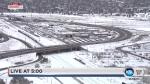
The slick and snowy roads contributed to dozens of crashes along Utah highways and streets, and it slowed some roads to a crawl. Westbound I-80 was shut down at 1300 East in Salt Lake City due to multiple crashes, the Utah Department of Transportation reported about 11 a.m., urging drivers to plan for delays and alternate routes.
Multiple crashes and slide-offs also backed up traffic for miles in Big and Little Cottonwood canyons as skiers and snowboarders headed to the slopes for the fresh powder. Both canyons closed at 10:45 a.m. for snowplows, but they reopened by noon.
"It'll be a journey today," Unified Police tweeted. "Lots of snow and heavy congestion."
The semi on I-215 at 6200 South in Holladay now blocking a right lane of main flow. His wheels are spinning in place, unable to move. pic.twitter.com/tCTMBepVaf
— Heather Kelly (@KSLHeatherKelly) February 19, 2018
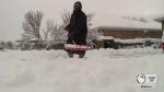
As excited as two skiers, David and Katie Zahn from Sandy, were about the fresh powder, they got caught in the morning chaos as they made their way up to Brighton Resort.
"The traffic jam this morning was terrible," David Zahn said. "It took us like an hour to get to the bus stop from our house, and we just live over on Highland Drive."
One snowboarder, Paula Williams, of Millcreek, said she had hoped to catch a bus to Brighton at 8:30 a.m., but she gave up and went home after seeing the long line of red tail lights snaking up the mountain.
“The traffic was crazy. I just went home," she said. She tried again after the canyons opened later in the afternoon.
Still, Williams was happy for the fresh snow.
“I wasn’t minding the mild winter, but considering I had, like, geared up for, you know, a good year back into snowboarding, I was kind of disappointed,” said Williams. “Hopefully, this year we get a little taste of why they call Utah snow ‘the best snow on Earth.'"
@NWSSaltLakeCity 9.0” in Cedar Hills pic.twitter.com/UoRLn6O6bZ
— M_Whirlybird (@mike_worlton) February 19, 2018
But with the fresh powder, the Utah Avalanche Center also warned of high avalanche danger near Logan, Salt Lake City, Provo and Skyline, and considerable danger near Ogden and in the Uinta Mountains.
As of Monday afternoon, 224 flights were delayed on average for more than an hour at the Salt Lake City International Airport, along with two cancellations, airport officials said.
Awesome snow removal crews are busy keeping the runways & taxiways clear for safe take offs and landings @slcairport . Plan extra time when traveling through SLC this President's Day--one of the busiest ever. Thanks to all airport workers who keep operations running smoothly✈️ pic.twitter.com/1gGchBcWtG
— SaltLakeCityAirport (@slcairport) February 19, 2018
As of about 11 a.m., about 3,900 customers in the Salt Lake metro area were without power, including about 2,300 in Taylorsville, said Rocky Mountain Power spokesman Dave Eskelsen.
Earlier Monday, about 7,000 customers had lost power due to the weather, including 4,500 in Salt Lake County and 2,000 in Davis County, Eskelsen said, but many had been restored by the afternoon.
"Crews have been working really hard since late last night, and they'll keep at it until everything's restored," Eskelsen said, thanking customers for their patience.
The National Weather Service projected snow accumulations of 8 to 14 inches in the Wasatch Mountain valleys, Wasatch Mountains south of I-80, the western Uinta Mountains and the Wasatch Plateau.
The Salt Lake and Tooele valleys were expected to have accumulations of about 1 to 3 inches, with more snow falling until Tuesday morning.
The storm comes amid an unusually dry and warm winter in Utah, but temperatures were projected to dip this week, with lows expected to reach about 19 degrees in the Salt Lake area Monday night. Tuesday was expected to reach a high of 27 degrees and a low of 14 degrees.
Contributing: Shara Park, Preston Cathcart