Estimated read time: 1-2 minutes
This archived news story is available only for your personal, non-commercial use. Information in the story may be outdated or superseded by additional information. Reading or replaying the story in its archived form does not constitute a republication of the story.
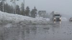
TAHOE — The water level at Folsom Lake rose at least 8 feet Sunday, thanks to heavy rainfall that fell steadily throughout the region, according to KRNV.
The National Weather Service expects the storm to taper off later Monday.

An area called Middle Peak, nine miles northwest of the Golden Gate Bridge in the Bay Area, received more than two feet of snow in five hours.
"The winter of 2013-14 has been a devastating one for most western states," said KSL meteorologist Kevin Eubank. "For much of the season a major area of high pressure over the West has blocked most of the storms that usually produce our winter precipitation. As a result snowpack levels across Utah have been well below normal."
Eubank mentioned the "Pineapple Express" effect bringing wet conditions from the Pacific to the mainland. "Over the last 7 days some spots in Utah have received over four feet of snow and seven inches of water. While this absolutely helps our snowpack, we need this stormy pattern to continue if we hope to finish the season at or above normal."
In Utah, the snowpack remained at below average levels throughout most of the state.