Estimated read time: 1-2 minutes
This archived news story is available only for your personal, non-commercial use. Information in the story may be outdated or superseded by additional information. Reading or replaying the story in its archived form does not constitute a republication of the story.
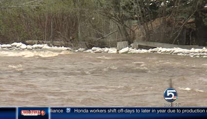
SALT LAKE CITY -- A flood warning remains in effect until noon Wednesday in Central Weber County.
That means flooding is imminent or already occurring. The South Fork of the Ogden River near Huntsville has risen to 4.9 feet. Flood stage is 4.6 feet.
Related:

Flood Watch River Flow Tracker
To track the water levels of creeks and rivers near you, go to our Live 5 River Flow Tracker.The river's water level is forecast to drop today but then rise again on Wednesday to 5.5 feet, which means even more significant flooding.
Experts warn residents living near the river to be cautious, especially at night when flooding is harder to see, and if it does occur, act quickly by moving to higher ground.
A flood watch is in effect for the following areas, meaning there is potential for flooding based on current forecasts:
- Cache Valley, including Logan and Smithfield
- The northern Wasatch Front, including Brigham City, Ogden, and Davis County
- The Wasatch Mountain valleys, including Park City, Huntsville, and Heber City
- The Wasatch Mountains north of I-80, including Snowbasin, Woodruff, and Randolph
The flood watch will remain in affect though Tuesday. If the weather changes significantly those flood watches could become flood warnings. Get the forecast here.
Mudslides are also a concern. Santaquin Canyon remains closed Monday morning because of a rock slide on Saturday.
Written with contributions from Shara Park .