Estimated read time: 4-5 minutes
This archived news story is available only for your personal, non-commercial use. Information in the story may be outdated or superseded by additional information. Reading or replaying the story in its archived form does not constitute a republication of the story.
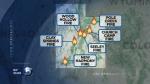
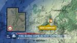
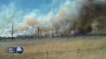
NEW HARMONY, Washington County — Multiple fires have been reported in central and southern Utah, with structures and communities in danger.
An out of control fire is burning east of New Harmony, with multiple structures and homes in risk of fire danger. There has been eight structures lost and one vehicle damaged. It is unknown if any of the structures were homes.
Evacuations have been reported for residents in the immediate fire threat area, including the Bumblebee Ridge Subdivision, the Kolob Section of Zion National Park and all areas north of New Harmony and south of Vandenberg Road, west of I-15.
The city of Kanarraville is no longer on alert for evacuation.
"If a fires starts going in Kolob — a beautiful canyon — it will have a lot of fuel there to burn. It could get out of control very fast," said Alyssa Baltrus, chief of interpretation at Zion National Park. "There are very steep areas. Anyone who has been to the area knows it's extremely rugged. It would be hard to fight."
As of 9:45 p.m., officials have allowed traffic to resume on I-15 and Old Highway 91. The roads were previously closed from milepost 42-51 as the fire made its way across I-15. Highway 144 will remain closed to non-residents.
Fire crews successfully contained spot fires east of I-15, with most of the fire now west of the interstate. As of 9:00 a.m., fire crew have made significant progress, containing about 60 percent of the fire.
The fire is said to be human caused, starting at approximately 1:50 p.m. At 4 p.m. the fire had burned an estimated 30 acres, but has since increased to approximately 2,000 acres as of 10 p.m. Wednesday.
Multiple agencies have reported to the New Harmony Fire, including officials with the Bureau of Land Management and the Cedar City Fire Department. Helicopters are working to contain the fire from above.
Individuals and families forced to evacuate their homes have now been asked to go to an LDS meetinghouse in Cedar City (155 East 400 South). Families can take their pets to the Diamond Z. Rodeo Arena, which is west of Cedar City on the south side of Highway 56.
One firefighter was burned with first- and second-degree burns, but was treated and released at a local hospital.
Clay Springs Fire
Another fire is quickly burning approximately 4 miles south of Oak City. The fire is currently moving in a north to northeast direction.
I could see flames. It looked like they were in town over the roof of another house, so I was pretty worried at that point.
–Sandra Wood
The cause of the Clay Springs Fire is currently unknown, but started at approximately 2 p.m. Witnesses said the fire grew by about five acres in 10 minutes, but has since increased to more than an estimated 12,000 acres as of 10 p.m. Wednesday.
Mandatory evacuations have been ordered for an estimated 850 residents in Oak City and the residents of Fool Creek. State Route 125 has been closed from state Route 132 to state Route 50 through Oak City. Evacuees are asked to meet at the LDS Stake Center on Sage Avenue, according to the Red Cross.
"I could see flames. It looked like they were in town over the roof of another house, so I was pretty worried at that point," said Oak City resident Sandra Wood.
Two firefighters have reportedly been taken to a nearby hospital because of second-degree burns.
"I guess the two guys in the back were unable to duck down low enough, so I guess the fire blew over the driver and hit the other two from what I've been told," said Oak City resident Randy Neilson, who has relatives fighting the fire.
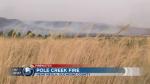
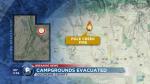
Pole Creek Fire
The Pole Creek Fire was reported about 3:30 p.m. It began near the mouth of Uintah Canyon on the Uintah-Ouray Indian Reservation. Federal, state and local fire crews fought the fire with two helicopters, a single-engine air tanker and numerous engines.
If this had been a cheatgrass fire, it would have been four times as big and running on us.
–Chris Secakuku
The Pole Creek Fire is located inside the burn scar of the Neola North Fire, which started June 29, 2007. The Neola North Fire killed George Houston, his son, Tracy Houston, and the man the Houstons had gone to buy hay from, Roger Roberson Sr. It also destroyed 12 homes and burned more than 43,000 acres.
Chris Secakuku, incident commander for the Pole Creek Fire, said crews were aided Wednesday by lessons learned from the Neola North Fire. The initial attack on the fire was well executed, he said, and native grasses planted after the 2007 fire prevented the Pole Creek Fire from growing rapidly.
"If this had been a cheatgrass fire, it would have been four times as big and running on us," Secakuku said.
Campers were evacuated from Uintah Canyon by the Duchesne County Sheriff's Office. The residents of several small communities to the east of the fire were put on notice, but were not ordered to evacuate.
Crews planned to work the fire until dark and then post lookouts to keep an eye on it overnight. The fire had burned about 160 acres and is human-caused, Secakuku said. It is under investigation.
More information will be posted about these fires when they become available.
Contributing: Geoff Liesik and Jed Boal


